Saturday, July 28, 2007

Interesting Finds Part I

This season, more than fifteen new sites were discovered in the Cilician plain. Most of these probably consisted of small farmsteads, manifested archaeologically by a dense concentration of ceramic wares distributed across the modern landscape in relatively limited surface areas. Once in a while, however, we stumbled upon significantly larger sites with seemingly more functional attributes. One of these was designated Site 161. This site was located on a hill slope and covered an area of ca. two and a half hectares. The first sign of the site came when we began stumbling upon an increasing amount of pottery sherds. Recently planted olive trees had caused the earth to be disturbed and a plethora of artifacts to rise to the surface. While a number of us were getting excited about the vast amounts of handles and bases that we were finding, Dr. Killebrew stumbled upon a number of large ashlar blocks a little further down the hill. The following picture shows a few of us standing on the remains of these monumental building blocks.


Further down the hill, we discovered the remains of another monumental building. In the picture below, you can discern two perpendicular walls, probably forming the corner of a room. Nearby villagers had directed us toward this area. They claimed that there used to be a Church in this area and that they had often stumbled upon mosaic fragments.


Although we found no mosaics, we stumbled upon three large chamber tombs cut into the natural bedrock. In the picture below you can see Pete crawling into one of these.

The next picture is a great shot of Rachel, crawling into the tomb head first.

As you can tell, this was no easy feat, but we were all too excited to turn down the challenge. Each tomb was constructed in a similar way. Three niches were carved into the bedrock inside the tomb: one on each side and one at the back. The following three pictures feature these little chambers:

From left to right: Dan, Pete, Rachel and Kathleen. Nothing like spending some quality time amongst friends in an ancient tomb...


...or perhaps a romantic evening... (Dan and Amanda)

Of course, creepy crawlies are a given in this kind of environment. Witness the horror/amusement at the sight of a VERY large and multicolored spider.

Our investigations however, were not all fun and games. Most of these tombs had probably been looted and very few artifacts were found within them. In one of the tombs we came across a number of bones.
In the picture below, Rachel is holding a skull fragment in her right hand and a vertebrae fragment in her left.
Our dear Müge, the only one who could stand upright in one of our largest tombs:

In addition to these finds, several other features were encountered, including a wine press, a possible ashlar quarry, two column shafts, and a column base. Most of the pottery collected from the site seems to date from the Hellenistic and Byzantine periods. This site may have consisted of a religious complex, including a Church, an administrative building, and agricultural dependencies. In my next post, I will share our discovery of an ancient canal system associated with the ancient site of Alexandretta, founded by Alexander the Great in the fourth century BCE.

Cheers!

Amanda*

Termessos

I wish I could tell you guys how many days ago we were in Antalya, but our trek from Hatay to Istanbul has been one gigantic whirlwind. I can recall that on our first full day in Antalya, we hired a driver to take us out to the ancient site of Termessos, of which Wikipedia provides a good summary.

Termessos is located about 30 kilometers north of Antalya in the midst of the Taurus Mountains. The site has not been systematically excavated, so the date of its earliest settlement is unclear. However, Termessos first entered the historical record in the 4th century BCE as it defied Alexander the Great, and was occuppied until its abandonment in the 5th century CE.

The picture below shows a view from the site.


We had heard that Termessos was spectacular, but there is no way to be prepared. On the trail from the parking lot to the site proper, I stopped to take a picture of this wall which was one of the oldest, most intact in situ wall I had ever seen.


Little did I know what else lay in store. The majority of this post is simply pictures of amazingly preserved structures that have survived for nearly 1500 years.

I have also included several pictures with members of our group to show the scale of some of these remains. Especially in North American archaeology, we are lucky to find the remains of post holes, and here, there are walls still several meters high.

The following pictures are from the gymnasium/bath complex of the city.


Termessos is famous for having a theater with one of the Classical world's best views. I guess I got a little carried away with it myself and forgot to get a good overall picture of the theater. However, the first picture below was taken from the back row towards the stage, with the enormous mountain towering in the background.


Another advantage Termessos has over a site like Ephesusm which is probably as equally well preserved, is that visitors can go anywhere they feel capable of. This is Amanda and Jeff sitting on the top of the wall at the back of the stage.


The scale in this next picture is difficult to discern, but this is a big passageway which runs under the theater seats to the stage.


By this time in our hike, our mistake in neglecting to bring along water started catching up with us. Fortunately, we had already seen some of the most spectacular ruins on the mountain. However, the path down to the parking lot took us through the necropolis. There were several plain sarcophagi which were passed up in exchange for quicker hydration. However, there were a few more elaborate tombs cut into the rock as pictured below.


That brings us to the end of Termessos. I think I speak for at least Jeff, Amanda, and myself in designating Termessos the most impressive site we have seen on this trip so far.

Tuesday, July 24, 2007

A typical afternoon in the lab

When we return from the field, the artifacts we collected while surveying have to be processed for study. As you might guess, after a few hundreds or thousands of years of existence, our pottery sherds are not exactly very clean. The first order of business is therefore to clean all artifacts to facilitate the identication and conservation process. Witness two enthousiastic pottery washers in the picture below.

The artifacts are then laid out to dry in seperate baskets. Each basket of artifacts is carefully labeled according to provenience. It is extremely important to conserve this organization. Without it, archaeologists would not be able to reconstruct the context within which the artifacts were found and their historical significance. The next step is to sort the artifacts. As you may gather from the two following pictures, artifacts are laid out on a table and organized.


Before going too far, let me take a step back and devote a few lines to the wonderful world of pottery. As Jeff mentioned in his blog, pottery constitutes the great majority of our finds, and this is true of most archaeological projects. While ceramic fragments may seem banal to many, they have great value to an archaeologist. Not only can they provide a means of dating a site, they can also supply a large amount of cultural information. For example, non-local pottery can point to the existence of trade; differences in local assemblages may betray dıfferent cultural practıces; a large number of coarseware and storage container fragments scattered throughout a small area may indicate a small farmstead rather than an elite or public building. Oftentimes, the majority of finds are undiagnostic, meaning that the appearance of the sherd does not provide enough clues to make any secure judgments as to its date or function. Diagnostic sherds include decorated pieces (painted or molded), rims, handles, bases, and any unusual fragments. These are diagnostic because they often enable us to recognize what kind of vessel is being observed and to place the find within a ceramic cultural and chronological typology.

Sorting the pottery on the table is a preliminary organizational step. Sherds are sorted according to whether they are body fragments, rim fragments, decorated pieces...etc.

Once this is accomplished, the experts swoop in and catalogue which time periods seem to be represented in a site's artifact assemblage. The picture below shows our two directors on the left, Dr. Ann Killebrew and Dr. Gunnar Lehman, laboring over the finds from one of our tell sites (blogpost upcoming!).

After the pottery reading, each artifact is marked with a fine black marker. The information includes the field season number, the site or collection unit number, and the individual sherd number. This system, though tedious, prevents any future confusion as to the provenience of the artifact in question. Below is a picture of Rachel, Florence, Lauren, and Amanda (from left to right) patiently marking pottery fragments. If you don't enjoy this type of detailed work, make sure you don't tell your field director that you have good handwriting!


The penultimate stage consists of drawing selected artifacts before they are bagged and placed into storage. Since the artifacts are not allowed to leave Turkey it is important to collect as much information as possible about a season's finds in order to be be able to perform analytical work in the intervening time. Of course, drawings are also important for publication purposes.

In the next post, we will give you a taste of some of our more exciting finds. As a teaser, I will mention an all time favorite: tombs... (and yes, bones too).

Cheers!

Amanda*

Thursday, July 19, 2007

A Typical Day in the Field...


Starts at 4:30am, when we stumble out of bed for a small breakfast – for me, usually a cup of orange juice. We then pack our gear and our second breakfast into the vans and leave our residence at 5:00 for whichever field or hill our glorious leaders have chosen to survey that day.

By 5:15, we have hopefully arrived. The first thing we then do is bum around while our aforementioned leaders decide exactly where we are going to survey. Often we take this opportunity to sit down and catch a nice view of the Turkish countryside:


The early morning on-site meeting must take place because our aerial (well, actually satellite) photos for this region are rather out of date and the fields have changed considerably, owing mostly to a large population increase in and around Iskenderun over the last few decades. Furthermore, we never know which fields will be plowed, planted, or completely overgrown and must adjust our survey coverage accordingly. In a perfect world, the areas surveyed would be chosen according to some highly statistical and very scientific formula, but here this is rather difficult.

In any case, once the field(s) has been chosen we spread apart in preparation for our survey. Distances between walkers vary depending on the width of the field and the size of the survey team, but generally our spread is between 10 and 30 meters.


When everyone is ready, we begin to walk. Surveying is not complicated: each surveyor tries to walk in a straight line, maintaining a consistent distance from those spread to his or her left and right, all the while searching the ground nearby for (most commonly) pottery sherds, roof tiles, or other evidence of ancient human activity. The best terrain for surveying is the plowed field, although we walk through almost anything. This includes the dread fennel – if you look closely in the first picture, you can see Kathleen’s red cap.


Amanda will have a post up soon documenting some of our more impressive finds, but here are a few pictures of some discoveries thus far:


A grindstone:


A small bit of Byzantine mosaic:


When the density of sherds becomes higher than just a few scattered here and there, the team regroups and searches the area, which is called a Site according to this project’s terminology. Here, we bag the pottery found in a separate collection and record the site’s boundaries (never an exact science), among other things. Often, the former is done by forming up in a much tighter line and walking across the site, picking up as many sherds as we see while one person searches for the site perimeter. The most common type of site that we’ve found thus far is the farmstead/villa, but in our survey area we also have a few tells:

Here is Pete marking the boundaries of a farmstead site with his handy GPS. As you see, these sites leave little in the way of structural remains:


After the GPS points are taken, it’s important to take notes describing what the points actually mark:


Here is one example of a tell – note the unnatural shape of the hill, especially its flat top, and the terracing on the lower part of the slope:


Occasionally we do a preliminary pottery sorting in the field. Most of the time, we only keep what are known as diagnostic sherds. That is, handles, rims, bases, and decorated pieces which allow ceramics experts (such as our glorious leaders) to identify the time period in which they were made and used:


Here is a small portion of the pottery found over the course of one day, once it has been washed and sorted:


We pause for breakfast at 9:30, and by this point we are already tired, sweaty, dirty, and hungry, as Rachel is here:


Although the plan is for a 30 minute break, we are usually a bit slower than that. At any rate, once we have eaten we pack up and head back out into the field for another two hours. When on survey, everyone must make sure to constantly drink water in order to avoid dehydration. I myself generally drink at least 3 liters, plus whatever juice there is available at breakfast, and as a team we bring out around 24 1.5 liter bottles of water each day. We finish at noon, when the sun is out in full force and the heat is almost unbearable. After lunch at 12:30, we have a few hours for siesta and then do work in the pottery lab – but that’s the subject of a future post.

Sunday, July 15, 2007

Last weekend, we all piled into our trusty dolmuşes and headed east.

Our first stop was Tilman Hoyuk, a site located only a few kilometers from Zincirli which we visited a couple of days earlier.


The preservation at Tilman Hoyuk is astonishing. Below is a picture of the site as it looks today. This portion of the site has not been excavated or conserved at all, yet you can still see several stone blocks left standing in place at doorway thresholds.


Our next stop was Yesemek, on which Amanda gave a short presentation. In the past, Yesemek was a stone quarrying and stone working site. Archaeologists working there have found statues representing nearly every stage of production from extraction to near completion. The picture below shows a representative portion of the site, which was covered in half finished status of all sorts of subjects. I believe these are sphinxes.


These three statues are of ancient twin mountain gods.


The actual quarry was further up the mountain. As intrepid archaeologists we just had to go all the way to the top. The picture below shows what the ancient quarry looks like. It is not very much like our modern day quarries which can eat away entire mountains, but more of an opportunistic exploitation of readily available material. If you look closely at the rock in the center of the picture, you can see that it was left after someone had already started carving.

Finally, for your own edification, this is what Yesemek looks like from the top of the mountain. If you squint and look in the parking lot, you can see one of our vans.
Next, we stopped in the city of Kilis to look briefly at some Ottoman architecture.

Following this, we left to go to the famous ancient city of Karchemish. This site nowadays straddles the Turkey-Syrian border at an international crossing, and is inaccessible to civilians. However, when we were asking for directions in the neighboring village, we met a local man who took us to a cemetery which overlooks the site. Due to the sensitivity of the site, though, we still refrained from taking pictures. It seems like this is one site you will have to come to Turkey to see for yourselves.

When we were on the road to Karchemish, we made a pit stop at a tiny village. Out of all the things I have seen on this trip so far, the architecture in this village tops the list. It is one thing to see an illustration of a mudbrick house from millennia ago, but it is another to see an inhabited one in person.


After thirteen grueling hours of travel in a hot dolmuş, we finally arrived in Birecik. Here is a picture of the group eating kebabs on the banks of the Euphrates River.


The next day, we started with a tour of Birecik. The next several pictures are of the old city walls, some of which have been since turned into habitations.


While we were looking at these walls, we just happened to run into the one man in probably the entire province who finds old houses to turn into museums. He took us to one late Ottoman house he was currently working on refurbishing. The first picture shows the house from the outside. It is the two stories above the shop.

Its entrance is on the next street over shown below.

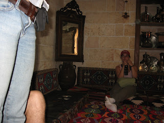
The next several pictures come from inside the house.


These next pictures were taken from the ruins of a fortification that overlooked the city of Birecik. This first one shows some of the remaining walls with the Euphrates flowing by in the back ground.
This is the older part of Birecik as seen from the ruins of the castle.

After Birecik, we traveled the site of ancient Seleucia, nowadays known as Zeugma. Below is a picture of most of what there is to see there. The damming of the Euphrates River just downstream from the site has caused significant portions of it to be lost beneath the waves of the new lake.
However, archaeologists did manage to execute a few salvage excavations before the waters literally washed over them. They found at Zeugma incredibly well preserved mosaics, which are now stored at Gaziantep Museum which claims to be the world’s largest mosaic museum. Below is a picture from the museum. To the left is a bronze statue of Mars which is close to life-size for a sense of scales
That is all from me for now. Look out for posts from Amanda and Jeff about the status of our survey in the field.